Maharashtra State Board Class 11 Geography Solutions Chapter 1 Earth Movements
1. Complete the chain.
A | B | C |
(1) Widespread volcanic eruption | (1) Zone V | (1) I to XII |
(2) Andaman and Nicobar Islands | (2) Fissure eruption | (2) Block Mountain |
(3) Mercalli scale | (3) Intensity | (3) Very high seismic vulnerability |
(4) Slow movements | (4) Faulting | (4) Solid |
(5) Philippines | (5) Volcanic bombs | (5) Deccan Trap |
(6) Volcanic material | (6) Circum Pacific belt | (6) Mayon |
A | B | C |
(1) Widespread volcanic eruption | (1) Fissure eruption | (1) Deccan Trap |
(2) Andaman and Nicobar Islands | (2) Zone V | (2) Very high seismic vulnerability |
(3) Mercalli scale | (3) Intensity | (3) I to XII |
(4) Slow movements | (4) Faulting | (4) Block Mountain |
(5) Philippines | (5) Circum Pacific belt | (5) Mayon |
(6) Volcanic material | (6) Volcanic bombs | (6) Solid 2. Identify the correct correlation. A : Assertion R : Reasoning
Question 2
Maharashtra Board Solution
A – Intensity of an earthquake is a measurement of the energy released during an earthquake. R – Mercallis scale is used to measure intensity of an earthquake. (a) Only A is correct. (b) Only R is correct. (c) Both A and R are correct and R is the correct explanation of A. (d) Both A and R are correct but R is not the correct explanation of A.
Solution & Step-by-Step Answer:
(c) Both A and R are correct and R is the correct explanation of A.
Question 3
Maharashtra Board Solution
A – South-East Asia, Japan and islands in the Pacific Ocean are most vulnerable to earthquakes and volcanic eruptions. R – They are located in ‘Ring of Fire’. (a) Only A is correct. (b) Only R is correct. (c) Both A and R are correct and R is the correct explanation of A. (d) Both A and R are correct but R is not the correct explanation of A.
Solution & Step-by-Step Answer:
(c) Both A and R are correct and R is the correct explanation of A.
3. Identify the correct group.
Question 1
Maharashtra Board Solution
|
A | B | C | D |
(1) Symmetrical Fold | (1) Black Forest | (1) Narmada Valley | (1) Caldera |
(2) Isoclinal Fold | (2) Vosges | (2) African Valley | (2) Crater Lake |
(3) Overturned Fold | (3) Himalayas | (3) Tapi Valley | (3) Cinder Cone |
(4) Recumbent Fault | (4) Satpuras | (4) Rhine Valley | (4) Lava Plateau |
C
4. Give geographical reasons.
Question 1
Maharashtra Board Solution
Extinct conical volcanoes often form crater lakes.
Solution & Step-by-Step Answer:
Extinct conical volcanoes often form crater lakes because-
Question 2
Maharashtra Board Solution
People living in the Himalayas are more vulnerable to earthquakes.
Solution & Step-by-Step Answer:
People living in the Himalayas are more vulnerable to earthquakes because-
Question 3
Maharashtra Board Solution
L-waves do not have a shadow zone.
Solution & Step-by-Step Answer:
L-waves do not have a shadow zone because-
Question 4
Maharashtra Board Solution
Soft rocks form folds while hard rocks form faults.
Solution & Step-by-Step Answer:
Soft rocks form folds while hard rocks form faults because –
Question 5
Maharashtra Board Solution
Folds depend on the strength of rocks and intensity of forces.
Solution & Step-by-Step Answer:
Folds depend on the strength of rocks and intensity of forces because-
5. Answer in detail.
Question 1
Maharashtra Board Solution
Explain different types of faults.
Solution & Step-by-Step Answer:
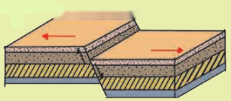
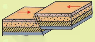
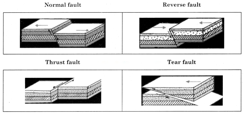
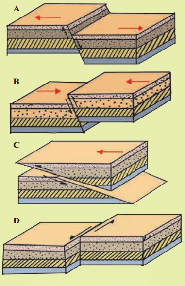
A fault is a fracture in the crustal rock, formed when the crustal rocks are displaced due to tensional movement caused by endogenic forces. The displacement of rock can occur in upward, downward or horizontal direction. The different types of faults determined by the direction of motion are: Normal fault: It results when a portion of land slide down along the fault plane and when the exposed portion of the plane faces the sky
Reverse fault: It results when a portion of the land is thrown upward relative to other side of the land. In such situation, the fault plane faces the ground.
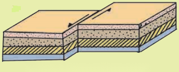
Tear fault: At times, the rock strata on either side of the fault plane do not have vertical displacement. Instead, movement occurs along the plane in horizontal direction.
Thrust fault: When the portion of the land on one side of the fault plane gets detached and moves over the land on the other side. The angle of fault plane is generally less than 45°.
Question 2
Maharashtra Board Solution
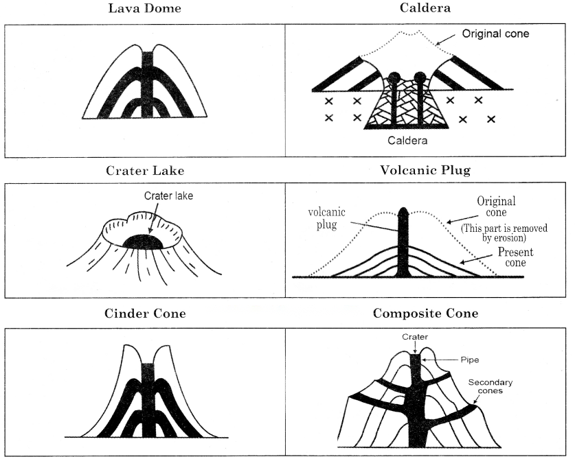
Explain with examples, different types of landforms produced by volcanic eruption.
Solution & Step-by-Step Answer:
A number of landforms are formed due to cooling and solidification of magma. Some important landforms are: Lava domes:
Lava plateaus: Caldera: Crater lake: Volcanic plug: Cinder cone: Composite cone:
Question 3
Maharashtra Board Solution
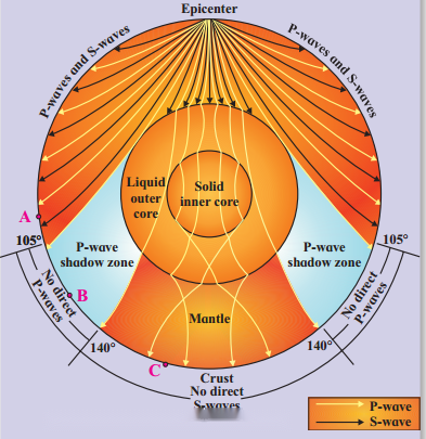
Explain the concept of shadow zone.
Solution & Step-by-Step Answer:
Question 4
Maharashtra Board Solution
Write a note on volcanic materials.
Solution & Step-by-Step Answer:
There are three main types of material which come out in volcanic eruptions namely liquid, solid and gaseous form. Liquid material:
Solid material: Gaseous material: 6. Differentiate between.
Question 1
Maharashtra Board Solution
Folding and Faulting.
Solution & Step-by-Step Answer:
Question 2
Maharashtra Board Solution
Normal fault and Reverse fault.
Solution & Step-by-Step Answer:
Question 3
Maharashtra Board Solution
Syncline and Anticline.
Solution & Step-by-Step Answer:
Question 4
Maharashtra Board Solution
Asymmetrical fold and Symmetrical fold.
Solution & Step-by-Step Answer:
Question 5
Maharashtra Board Solution
Mercalli scale and Richter scale.
Solution & Step-by-Step Answer:
Question 6
Maharashtra Board Solution
Slow movements and Sudden movements.
Solution & Step-by-Step Answer:
7. Draw a neat and labelled diagram.
Question 1
Maharashtra Board Solution
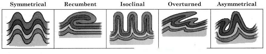
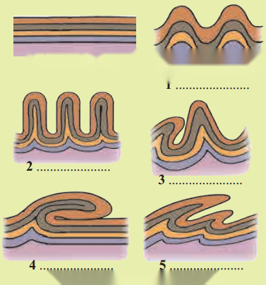
Types of folds
Solution & Step-by-Step Answer:
Question 2
Maharashtra Board Solution
Types of Faults
Solution & Step-by-Step Answer:
Question 3
Maharashtra Board Solution
Shadow zone
Solution & Step-by-Step Answer:
Question 4
Maharashtra Board Solution
Volcanic landforms
Solution & Step-by-Step Answer:
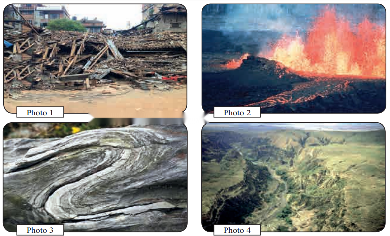
11th Geography Digest Chapter 1 Earth Movements Intext Questions and Answers Let’s recall (Textbook Page No. 1) 1. Observe the following pictures in fig 1.1 and discuss the questions.
Question 1
Maharashtra Board Solution
What might be the reasons behind buildings collapsing in photo 1?
Solution & Step-by-Step Answer:
The major reason behind the buildings collapsing in photo 1 is the occurrence of earthquakes.
Question 2
Maharashtra Board Solution
Which event in depicted in photo 2? What impact does it bring about in the surroundings?
Solution & Step-by-Step Answer:
The volcanic eruption and flowing of lava is depicted in photo 2. Heavy loss of life and property is experienced when the lava flows to the surrounding area.
Question 3
Maharashtra Board Solution
In photo 3, what could be the reason behind the bend in the rock strata?
Solution & Step-by-Step Answer:
Due to compression of sediments within the earth’s interior and pressure from overlying layers the rock strata seems to be bended.
Question 4
Maharashtra Board Solution
What could be the reason behind the difference in altitudes of the land and the steepness of the slope in photo 4?
Solution & Step-by-Step Answer:
The reason could be displacement of rock due to vertical movement. It may form plateau on block mountains.
Question 5
Maharashtra Board Solution
Classify the events in the photos into sudden and slow movements.
Solution & Step-by-Step Answer:
Sudden movements are earthquake and volcanoes in photo 1 and 2. Slow movements are formation of folds and formation of plateaus or block mountains in photo 3 and 4.
Question 6
Maharashtra Board Solution
Example of which of these movements is not likely to be found in the mainland of Indian sub- continent?
Solution & Step-by-Step Answer:
The volcanic eruptions are not found in mainland of India sub-continent.
2. On 19th August, 2018, around 300 people died in Indonesia. Many buildings collapsed. Many roads broke apart. A tsunami was generated. (Textbook Page No. 6)
Question 1
Maharashtra Board Solution
What was the cause behind these events?
Solution & Step-by-Step Answer:
Collision of tectonic plates was the causes behind the events.
Question 2
Maharashtra Board Solution
What actually happened during this natural event?
Solution & Step-by-Step Answer:
A very high intensity earthquake struck north eastern parts of Indonesian coastline, where subsequent landslides into sea triggered tsunamis.
Question 3
Maharashtra Board Solution
Name the energy waves involved in this natural event.
Solution & Step-by-Step Answer:
Tsunamis were involved in this natural event where the tectonic plates moved horizontally.
Question 4
Maharashtra Board Solution
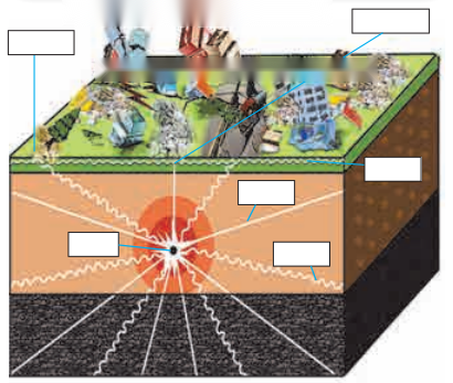
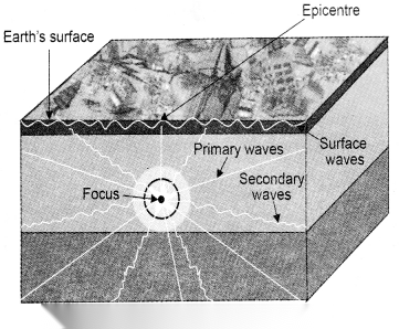
Observe the diagram in fig. 1.9 and label the boxes.
Solution & Step-by-Step Answer:
Think about it.
Question 1
Maharashtra Board Solution
How will compressional forces affect brittle rocks? (Textbook Page No. 3)
Solution & Step-by-Step Answer:
The compressional forces will break the brittle rocks into pieces.
Question 2
Maharashtra Board Solution
A mountain never remains a mountain’. Can you relate this idiom with the mountain building process? (Textbook Page No. 4)
Solution & Step-by-Step Answer:
This happens because of continuous erosional activities taking place on the mountain sides. Running water glaciers, wind, volcanic activities keep on changing the surface of a mountain.
Question 3
Maharashtra Board Solution
When can faults form is fold mountains? (Textbook Page No. 6)
Solution & Step-by-Step Answer:
If compression takes place along the faults, folds can be formed.
Question 4
Maharashtra Board Solution
Can folds form into block mountains? Find the reason and discuss. (Textbook Page No. 6)
Solution & Step-by-Step Answer:
No, folds cannot form into block mountains because folding takes place due to compression of elastic rocks and block mountains are formed due to displacement of rocks owing to tension.
Question 5
Maharashtra Board Solution
Look at fig.1.10 and answer following questions. During an earthquake, do you think the seismic waves reach entire portion of the earth. Is there any region on the earth’s surface where a given earthquake will not be reported? (Textbook Page No. 6)
Solution & Step-by-Step Answer:
It’s the shadow zone of P-waves and S-waves where the seismic waves do not reach. No there is no region on the earth’s surface where a given earthquake is not reported.
Question 6
Maharashtra Board Solution
Why has the shadow zone for L-waves not been shown in fig 1.10? (Textbook Page No. 7)
Solution & Step-by-Step Answer:
L-waves travel through the circumference of the earth. Thus, they do not been form shadow zone.
Try this.
Question 1
Maharashtra Board Solution
Observe the diagrams in fig. 1.5. Try to understand the different types of fold shown in the diagram. Write the name of the fold. (Textbook Page No. 4)
Solution & Step-by-Step Answer:
Question 2
Maharashtra Board Solution
Observe the diagram in fig. 1.6 and read the explanation regarding the characteristics of various faults given. Identify the faults and match each of them with their characteristics. (Textbook Page No. 5)
Solution & Step-by-Step Answer:
A – Normal fault B – Reverse fault C – Thrust fault D – Tear fault
Can you tell? (Textbook Page No. 7) In fig 1.10 textbook page 6 A, B, C are three points on the earth’s surface. Analyse their location with respect to epicentre and shadow zones (ii) ‘B’ point is in shadow zone because both the waves do not reach there. P waves pass through all mediums, they experience refraction as they pass on one medium to another. The seismograph records P waves, which is located away from ‘B’ point. But P waves are not recorded in an area between 105 and 140° from epicentre. The S waves also do not reach here. Therefore, it is called ‘Shadow zone’ of Earthquake waves. (iii) ‘C’ point is in the area of the shadow zone of ‘S’ waves, that in within 140°. P waves reach beyond 140°. Since ‘S’ waves do not reach here, it is called ‘Shadow zone of S waves’.
Question 1
Maharashtra Board Solution
On the basis of the intensity of damage risk, India is classified into five risk zone. Use the given weblinkpdf and complete the table given. (Textbook Page No. 9)
Solution & Step-by-Step Answer:
Read the following passage about Krakatoa volcanic eruption and answer the following questions. (Textbook Page No. 10) There is an island known as Krakatoa between the islands of Java and Su matra in Indonesia. There were frequent volcanic eruptions here. From May 1883, massive explosions began. The eruption that took place at about 10 in the morning on 28 August 1883 was the largest ever recorded explosion. As a result of this explosion, the entire island disappeared. During this eruption, rock particles and dust thrown up in the atmosphere was about 25 km³. The column of this dust-ash rose as high as 80 km. The discharge of Krakatoa threw into the air nearly 21 km3 of rock fragments, and large quantities of ash fell over an area of some 800,000 km². Near the volcano, masses of floating pumice, were so thick that ships had to halt. The surrounding region was plunged into darkness for two and a half days because of ash in the air. For some years after this, cloud kept moving round the earth. About 36,000 people died in these eruptions and the tsunami waves created by it. In 1927, volcanic eruptions began at the same place and a new island rose in place of the Krakatoa island that had vanished. It was named Anak Krakatoa’ or ‘Child Krakatoa’. The volcano here constantly emits ash and steam. This new island has now become a laboratory for geologists and biologists.
Question 1
Maharashtra Board Solution
Make a list of materials that came out during eruptions.
Solution & Step-by-Step Answer:
Rock, particles, dust, ash, floating pumice, steam were the materials that came out during eruption.
Question 2
Maharashtra Board Solution
Classify them into liquid, solid and gaseous forms.
Solution & Step-by-Step Answer:
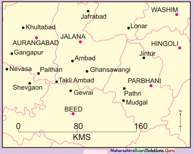
Find out! (Textbook Page No. 9) Find out examples of active, dormant and extinct volcanoes. Give it a try (Textbook Page No. 8) Take the given hypothetical data in the table. The data shows the time of arrival of P-waves and S-waves at 3 seismograph stations. Assume the scale of the map as 1 cm : 18 km. See fig. 1.11.
Answer: Second Step : Find out distance on land between Jalana and Epicentre Third Step : Find out radius for Jalana Station. Fouth step : Now draw circles around Jalana, Washim and Aurangad with the help of radius calculated.
|